munich - MSc Topics

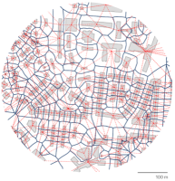
To learn a map generalization model for building footprint simplification and aggregation with deep learning, and to proper encode and learn polygon geometries

develop conceptual models and practical examples for the implementation of a City Energy Performance Dashboard in the contextual background of energy transition

The goal of this thesis is to establish a visualization pipeline for pre-classified point clouds in order to make visual representations of LiDAR data easily un
, Geography and Map Division, Library of Congress")
In this topic, the possibilities and limitations of the influence of new AI solutions will be examined and researched in order to support and promote cartograph
The goal of this thesis is to develop a spatial mapping approach for slums toward SDG 11 using urban morphology and topology technique.

The goal of this thesis is to investigate the impact of label placement in mixed reality environments, identifying optimal strategies that enhance spatial knowl
.")
The goal of this thesis is to quantify the perceived complexity and cognitive load caused by virtual symbol and label density and evaluate their influence on th

To develop interactive maps at different scales (spatial, temporal, and spectral) highlighting the condition and the factors that produce stress in plants resul

The goal of this thesis is to explore and identify the risk factors of active mobility in urban environments with multi-source data, extract the knowledge there

To analyze user editing patterns, e.g., user focus of geospatial extent, editing frequency.
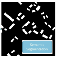
Develop and evaluate an instance segmentation approach for the extraction of area features from historical map scans and investigate the scalability.

This thesis aims to incorporate visual effects to facilitate depth perception in Mixed Reality (MR).
To develop a semi-automatic mapping tool able to calculate the snow cover fraction area at a small scale.