Developing and implementing a workflow for a new global dataset for high resolution travel time
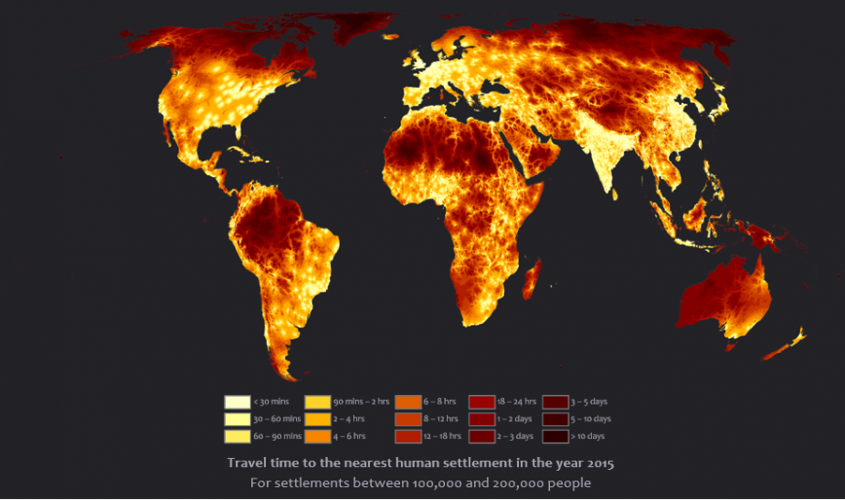
 Travel time to the nearest human settlement from anywhere on the planet in the year 2015
Objective:
Keywords:
 See above. This illustration will eventually be replaced.
Description:
Research Theme *
STAMP / FORAGES / CRIB (see below)
Additional remarks (optional)
This project will be carried out in collaboration with Andy Nelson (NRS) and Serkan Girgin (CRIB). They would have featured in the list of staff above if this web page would allow.
Upscaling a derived data set is an ambitious, challenging and non-trivial task. With this project, we aim to improve the spatial resolution of this fundamental global dataset by a factor ten. This means that associated datasets typically increase by a factor 100. Handling such data wisely is one concern. But, at different resolutions also different spatial features come into play: a motorway no longer is a stretch of concrete from A to B, but it has exits with on and off ramps, and distinctions between 2-, 3- and 4-lane carriageways may become important. Thus, also the data model itself requires a review. Finally, the computations from the base data to produce the travel friction grid will require careful scrutiny: with so much more base data, the computational complexity of the chosen algorithms will be an important factor of success.
If time allows, we may also want to address another characteristic of current models. They do not perform so well in hilly and mountainous areas. (In a 1km2 grid cell a mountain road may have four hairpins, for instance.) These models apply terrain slope in a rather crude way, which causes higher systematic error in travel time forecasts over undulating terrain. The current models are independent of direction of travel. While slope is an important determining factor of cruising speed, regardless of travel mode, more sensible models shall account for the interplay between slope angle, aspect and travel direction.
In short, there are numerous challenges in this exciting project. The product that we aim to develop has many applications, and holds promise to become a flagship dataset.
There is no fieldwork in this topic.
The candidate must have good programming skills for this topic, preferably competence in data extraction and geospatial computing in Python. We are keen to discuss the options with any serious candidate.

