Simplification and aggregation of vector building footprints using deep learning models
Objective:
Keywords:
 Aggregation of building footprints
Description:
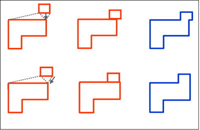
Map generalization is one of the most fundamental tasks in cartography. Recent advances indicate that deep learning models are a promising research direction for map generalization. Raster-based solutions require rasterized maps, which are less than ideal, but allow for multiple operators to be realized simultaneously. Until now, vector-based solutions can only solve the simplification problem without taking into account adjacent or neighboring geo-entities. In this thesis, we aim to explore a possible vector-based solution for map generalization considering both simplification and aggregation of building footprints.
Staff involved: Yu Feng (y.feng@tum.de)
References:
Vaswani, A., Shazeer, N., Parmar, N., Uszkoreit, J., Jones, L., Gomez, A. N., ... & Polosukhin, I. (2017). Attention is all you need. Advances in neural information processing systems, 30.
Zhou, Z., Fu, C., & Weibel, R. (2023). Move and remove: Multi-task learning for building simplification in vector maps with a graph convolutional neural network. ISPRS Journal of Photogrammetry and Remote Sensing, 202, 205-218.
Feng, Y., Thiemann, F., & Sester, M. (2019). Learning cartographic building generalization with deep convolutional neural networks. ISPRS International Journal of Geo-Information, 8(6), 258.
Domain(s):
Study Program(s):
- MSc. Cartography (EXCLUSIVELY externally advertised)
